Urban land and natural habitats both play an important role in preserving biodiversity. The diversity of wildlife species present depends largely on the presence of open water and wide variety of native vegetation. Proximity to Illinois Nature Preserves and other natural areas increase the likelihood that animals will use developed properties, indicating that urban areas are part of the continuum of habitat necessary for animal survival.
Lake County is home to a diversity of species, as well as ecosystems. Each habitat type provides requirements upon which specific groups of animals depend for survival.
Moving Waters
A continental divide runs through the heart of the Chicago region. The Des Plaines and Kankakee Rivers join to create the Illinois River, which flows to the Mississippi. The Fox River also joins the Illinois River. The Chicago, Grand Calumet, and Little Calumet Rivers flow into Lake Michigan. Rare and endangered fish and mussels still live in the best of our rivers. Learn more »
The use of rivers by living things is largely controlled by physical and chemical factors. Physical factors include the size of the river and the amount of water flowing through it, the consistency of the flow, the speed of the current, and the nature of the bottom. Chemical factors in our region are mostly about the extent of pollution.
Biologists have divided the rivers of the Chicago region into four size categories. The smallest of these is the headwater stream, a tiny creek that may flow only intermittently. Low order streams are small- to medium-sized creeks whose bottoms have been shaped by the water to produce riffles and pools, alternating sections of fast shallow water and slow deep water. Mid-order streams are our most complex river habitat. Water flows through both deep and shallow pools. Floodplains begin to develop along streams of this size. Our largest rivers, such as the Des Plaines, have broad floodplains. Floodplains are low lands adjoining the river channel that are regularly flooded during periods of heavy flow, such as early spring. The flooding exerts a heavy influence on vegetation along the banks of large rivers.
Preserves with moving waters: Des Plaines River Trail and Greenway, Fox River, Grassy Lake, Independence Grove, Lake Carina, Middlefork Savanna, Van Patten Woods
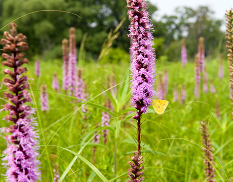
Prairies
Prairies are communities dominated by grasses on organic or mineral soils. Trees may be present, but less than 10% of the area has tree cover. Four natural communities are recognized based on soil type: fine-textured-soil prairie, sand prairie, gravel prairie, and dolomite prairie. Soil moisture gradients for each of these prairie types range from dry to wet (except that gravel prairies range only from dry to mesic). Learn more »
Prairies are grasslands. The dominant plants are grasses—although many other kinds of plants are present. Most of the biomass, the living material, of prairie grasses and wildflowers—is underground. On deep soils, the root systems of some prairie species extend nearly 20 feet below the surface. They may live for decades, each spring sending up new green shoots to flower, set seeds and die.
Grasslands develop on flat lands in areas where long periods without rainfall are common—like summer droughts of the American Midwest. Periodic droughts and the flat ground that offers few obstacles to advancing flames have made fire a major force in the ecology of the world's grasslands. Millions of years of evolution in the presence of fire have made the tallgrass prairie dependent on periodic fires for its survival. Without fire, prairies are invaded by trees and shrubs that kill the prairie plants with their shade. In the presence of fire, prairies are very stable communities.
During the past 175 years, millions of acres of tallgrass prairies have been converted to cornfields or covered with building. The tallgrass prairie survives in tiny fragments. Hope for the survival of this ecosystem rests on good management of these fragments and on restoration projects that return prairie to lands where it has not grown for a century or more.
Preserves with prairies: Grant Woods, Lyons Woods, Middlefork Savanna, Rollins Savanna
Still Waters
Lakes are permanently, not just seasonally, wet. They are too deep for rooted plants to grow except in shallow, near-shore areas. The distinction between a lake and a pond is a matter of size. Learn more »
Lakes are bodies of water large enough to have at least one wind-swept beach. When winds are high, they blow across the water and create waves large enough to wash away any plants attempting to colonize the beach. Lakes and ponds can be divided into categories based on abundance of nutrients and how these nutrients are cycled through them.
Our inland lakes are generally of moderate depth. One in Lake County, reaches a depth of 50 feet and has been named Deep Lake. Thirty to 35 feet is a more usual depth.
Lakes are ecologically complex communities with several distinctive kinds of organisms living in them. Healthy lake communities have animals at different trophic—that is, feeding—levels, from herbivores to top carnivores. Fish-eating birds such as cormorants and terns enter the picture as predators.
Lake Michigan
The Great Lakes are among the wonders of the world. The five inland seas hold one-sixth of the world’s surface fresh water. Lake Michigan is the third largest of the lakes with a surface area of 22,300 square miles.
Preserves with still waters: Captain Daniel Wright Woods, Fort Sheridan, Fourth Lake, Greenbelt, Half Day, Lakewood, Sun Lake
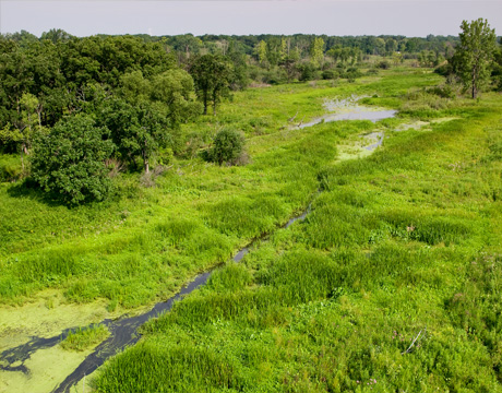
Wetlands
In geological terms, our landscape is very young, having just emerged fro under mountains of ice or lakes or water. Substantial parts of our landscape are very poorly drained or don't drain at all. Water either sinks into the ground or evaporates. Undrained depressions with no outlets—or with outlets that function only during periods of very high water—are scattered over the entire region. Learn more »
This young landscape, combined with the many layers of varied deposits left by the glaciers and by post-glacial lakes, produces one of the most diverse collections of wetlands in North America. Some wetlands are submerged year round. Others are wet in spring and early summer and dry by August. In some wetlands, water can be hip-deep. In others, the soil is saturated but little or no water stands above the surface. These differences exert a powerful influence on the vegetation of a wetland. The vegetation, in turn, exerts a major influence on what animals live there.
Lake, shrub swamp, floodplain, river marsh, sedge meadow, fen and bog are all types of wetlands that are distributed across the Lake County landscape.
The Chicago region has one of the most diverse collections of wetlands in North America. The regional community-classification system recognizes six major categories of wetlands: marsh, bog, fen, sedge meadow, panne and seeps and springs. In addition, wet prairie is often considered a wetland type. All wetlands are inundated or saturated by surface or groundwater for a sufficient part of the year to support vegetation that is adapted to life in saturated soil. The vegetation, the amount of water they hold and the chemistry of their soil and water define the different wetland types.
Preserves with wetlands: Almond Marsh, Cuba Marsh, Marl Flat, Middlefork Savanna, Prairie Wolf, Rollins Savanna, Sedge Meadow
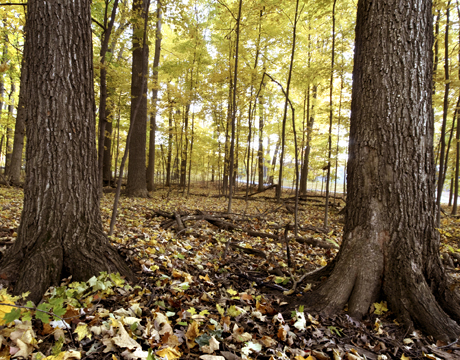 Wooded Communities
Trees in the Chicago region once grew as lone sentinels on the prairie. They grew in open groves and sun-dappled woodlands. These wooded communities varied over time and space. They blended into each other on their borders. The categories we have created to describe them are only rough descriptions. Learn more »
The classifications scientists use to describe natural communities give a short, simple name to a very complicated thing. When we talk of "oak savannas" or "oak-hickory forests," we are referring to communities that may include hundreds of species of plants, and—when you add up all the beetles, spiders, snails, and centipedes—thousands of species of animals. When we study a natural area and decide what communities are present, we lok at the entire biota, all the living things. Overall differences in the biota tell ecologists whether a given community developed as an open woodland or a dense forest. The biota also help us identify communities that have been seriously harmed by the changes that large scale settlement has brought.
All of our wooded communities have been changed by the altered conditions that have followed settlement. The suppression of fire, in particular, has had a profound effect. With fire gone from the community, fire sensitive trees have moved into oak forest, open woodlands and savannas, casting dense shade and alterning our wooded communities. Fortunately, restoration can reverse this trend.
The forested community class includes all the community types that are dominated by trees, with an average canopy cover of greater than 50%. Forest communities have a multi-layered structure composed of the canopy, sub-canopy, shrub, and herbaceous layers. Historically, this multi-layered structure was maintained through fires and other natural disturbances. Within the forest community class there are four community types: upland forest, floodplain forest, flatwoods, and woodlands. Woodlands developed under a canopy cover of 50-80%, intermediate between that of savanna and forest.
We are a member of Chicago Wilderness, a regional alliance that connects people and nature. The Atlas of Biodiversity is a richly illustrated introduction to the endangered natural communities of the Chicago Wilderness region, including descriptions of tehse endangered communities, how they sustain themsleves through ecological processes, and how natural forces—and people—have shaped them over thousands of years.
Preserves with wooded communities: Captain Daniel Wright Woods, Des Plaines River Trail and Greenway, Edward L. Ryerson Conservation Area, Ethel’s Woods, Grant Woods, Half Day, Independence Grove, Lyons Woods, MacArthur Woods, McDonald Woods, Van Patten Woods
We are a member of Chicago Wilderness, a regional alliance that connects people and nature. Chicago Wilderness is 200,000 acres of protected conservation land—some of the largest and best surviving woodlands, wetlands, and prairies in the Midwest. It is also the much larger matrix of public and private lands of many kinds that support nature in the region along with the people who protect and live compatibly with it. Chicago Wilderness has created a Biodiversity Recovery Plan and The Atlas of Biodiversity for our region. These are great resources for further information regarding the importance of our region's biodiversity, detailed information of natural, and how natural forces—and people—have shaped them over thousands of years.